

Why Monitor Stockpiles Aerially through Drones or LiDAR?
Modern industries demand accurate, safe, and real-time stockpile measurement— something traditional ground surveys struggle to provide. Drone for measuring stockpiles offers a faster, more efficient solution for monitoring material movement, inventory changes, and blending consistency.
With advanced drone stockpile measurement software and UAV digital stockpile monitoring, businesses can:
- Track random stacking and reclaiming activities in real-time.
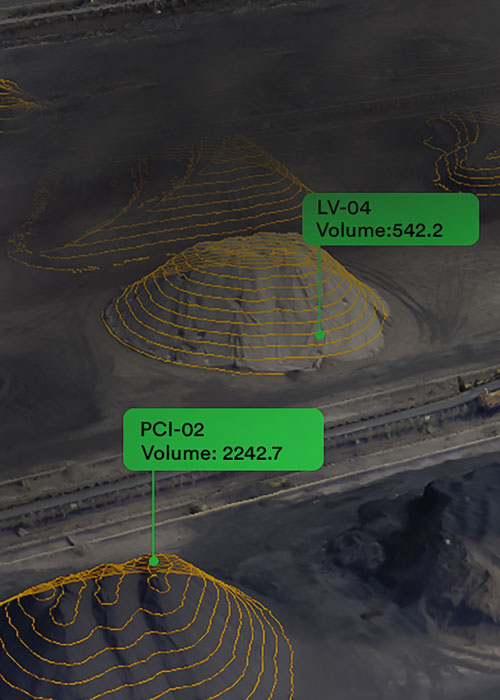
- Enable real-time stockpile volumetric tracking to monitor volumes as they change.
- Perform drone-enabled stockpile quantity assessment at regular intervals to avoid losses.
- Get precise height, shape, and terrain data with less effort.
- Generate automated alerts for overflow or low-stock conditions.


Benefits of Advanced Drone-Based Stockpile Management
Using drone-based stockpile management techniques brings a range of advantages:
- Accurate stockpile measurements without human error.
- Improved safety with fewer ground-level site visits.
- Reports ready within hours, not days.
- Cost-effective alternative to manual surveys.
- Fewer CSR (Corporate Social Responsibility) risks due to better documentation.
Manage your stockyard and
stockpiles
in a smarter way
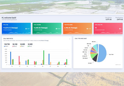
Intelligent Dashboard
 Real Time Stockpiles Volumetric
-
Material Locations Allocation
-
Smart Stacking & Reclaiming
-
Ensuring First In & First Out
-
AI based data Analytics
-
Notifications & Alerts
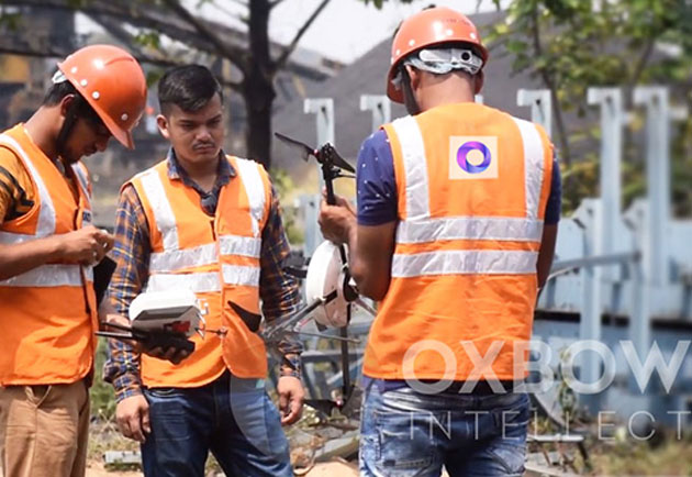
Aerial & Scanner based Field Inspection
 Drone based Stockyard Inspection
-
Total Station & 3D Laser Scanner Inspection
-
Accurate Material Volumetric Estimation
-
Bulk Density Analysis & Quantity Estimation
-
On-site Condition & Compliance Verification
High End Data Processing
-
3D Point Cloud Generation & Classification
-
Digital Terrain Model (DTM) & Digital Surface Model (DSM) Creation
-
Orthomosaic & High-Resolution Imagery Processing
-
Change Detection & Comparative Analysis
-
Geospatial Data Integration with GIS & CAD Platforms

Oxyard Pro
- 1 Fewer CSR (Corporate Social Responsibility) risks due to better documentation.
- 2 Keeps track of stacking and reclaiming activities in real time.
- 3 Follows FIFO method to make sure older stock is used first.
- 4 Gives clear, step-by-step instructions for reclaiming minerals.
Want to Manage Stockpiles Smartly?
Book a Demo© Oxbow Intellect. 2026 All Rights Reserved