Hassle-free Land Inspections with the Oxland App

Land shapes cities and feeds global dreams every day. When owners, builders, and officials handle land with paper files, confusion grows and money slips through unnoticed. Many villages still hold bulky registers that fade in rain, and metropolitan projects stall because teams cannot trace a single missing deed. Yet land fuels housing, roads, and clean-energy plans that power progress across continents.

Modern projects need faster, clearer land management tools now. That is why many forward-looking teams choose OxLAND, a digital land management platform that turns static records into living insights. The service blends land management services with friendly dashboards, giving everyone equal visibility into maps, documents, and timelines. With one sign-in, engineers, farmers, and officers speak the same language of lines, colors, and clear milestones.

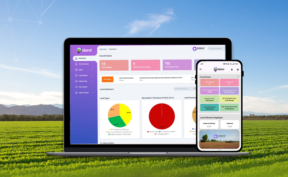
A Quick Tour of OxLAND

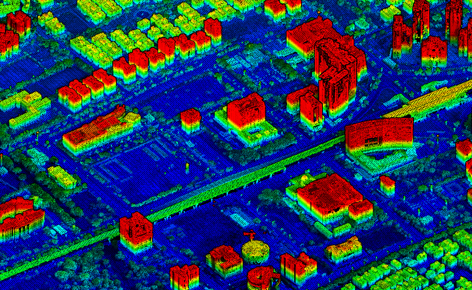
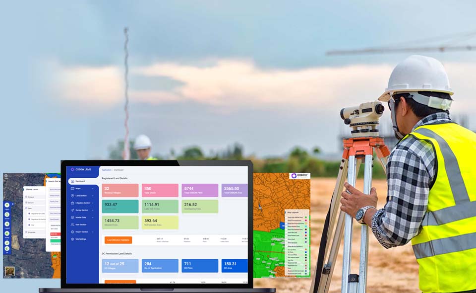
OxLAND sits in the cloud and works everywhere easily. The system merges GIS mapping, land records management, and swift document workflows, creating a single source of land truth. Its design follows strict security rules, and every click leaves an audit trail that protects public trust. You open one parcel and instantly view historical deeds, encumbrances, survey sketches, and the latest satellite frames.

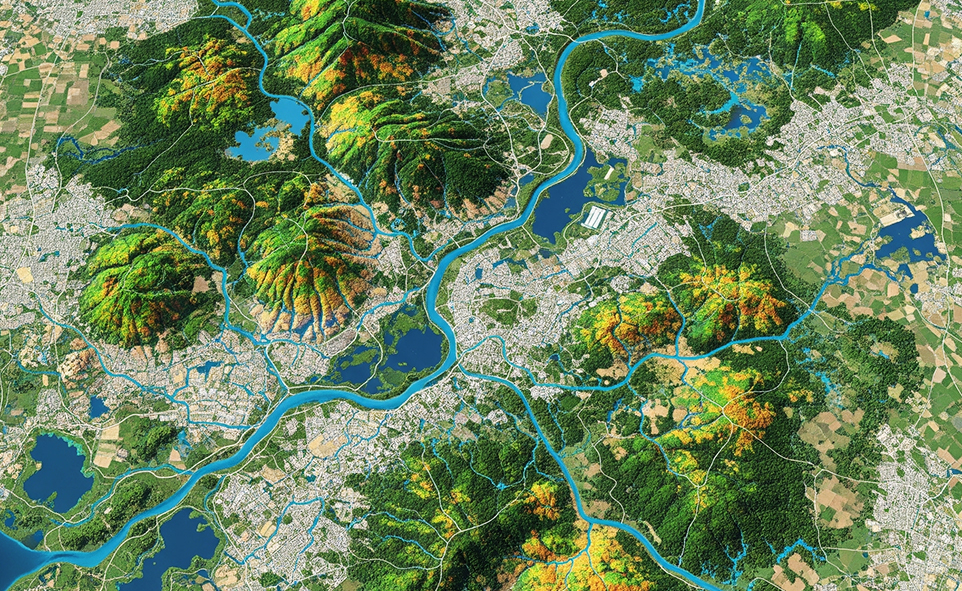
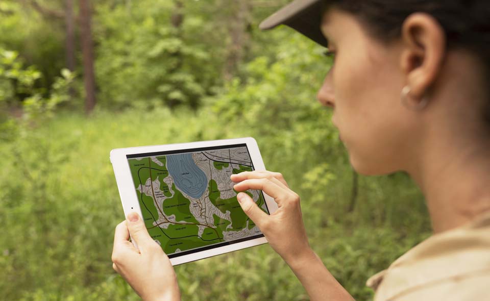
Users log in from any device, open interactive maps, and track every plot from the first survey to the final handover. Nothing hides, because the dashboard lights up every detail. Color layers reveal zoning, risk buffers, soil grades, and road alignments, while alert banners highlight parcels that demand quick action. A clear filter bar helps inspectors find land allotments, compensation files, or litigation cases within seconds.

Behind the scenes, OxLAND integrates land survey and mapping services to feed high-resolution images straight into the map canvas. You see terrain shifts before problems grow large today. The platform also taps drone-based surveillance for frequent flyovers that update contours and detect new encroachments. Machine-learning routines then compare fresh images with baseline plans and flag mismatches that teams can solve quickly. Field engineers upload results from GIS & mapping services, and supervisors view them live without extra software. It also offers UAV-based land survey and mapping services for large, hard-to-reach sites.

Benefits that Touch Everyone

Every stakeholder gains real wins from this digital approach. Because the platform stores, analyzes, and shares data in seconds, it removes the friction that slows land projects. Better still, it cuts costs that usually vanish into travel, manual sketches, and endless photocopies. The list below shows how one LRMS solution delivers direct value to businesses, landowners, PSUs, and governments together:

  • You cut acquisition cycles because OxLAND maps parcels, tracks payments, and flags every legal milestone in one view.
  • Landowners view clear boundaries, receive timely alerts, and get fair compensation supported by audit-ready digital proof.
  • Public-sector units manage large land banks, coordinate on-the-ground teams, and watch encroachment hotspots shrink through live imagery.
  • Officials speed up permit approvals, enforce zoning rules, and publish transparent reports that boost citizen trust and project momentum.
  • The built-in Litigation Management Solution links cases to parcels and reminds teams before hearings slip past.
  • R&R management keeps resettlement promises on schedule and shows each family exactly when and how benefits arrive.
  • Automated liaising and coordination workflows share updates with vendors, surveyors, and departments without endless calls or travel.
  • Drone-based surveillance and encroachment monitoring catch illegal construction early, protecting public funds and private land alike.
  • OxLAND integrates with ERP systems so finance teams can view real-time land costs and tune budgets instantly.
  • Continuous land records digitalization means field teams scan documents once, and the data stays safe and searchable forever.
  • Built-in document management tags leases, No-Objection Certificates, and title deeds, linking each file to its rightful geofence.

These wins stack up and reshape entire development timelines. Instead of waiting months for scattered records, stakeholders turn information into action the same day they discover an issue.

Good land management software solutions also save the planet, because smarter zoning reduces waste and protects fragile habitats. OxLAND makes responsible growth the easy default choice for everyone. When decision makers view up-to-date maps, they reroute access roads around wetlands and schedule tree replacement before boilers fire up. Less guesswork means fewer diggers idling on site, and that simple change cuts fuel use and community noise.

Conclusion

Great land projects start with clear, shared land knowledge. If you want to replace paperwork pain with progress, explore OxLAND today and watch your land work smarter. From land acquisition management to land parcel monitoring, the app gives you the tools that tomorrow’s world already demands. Land shapes futures, and OxLAND keeps those futures secure, one bright, precise map at a time.

How GIS and Drone Technology Boost Profit Across the Solar Project Lifecycle

Solar projects are getting bigger, and so are the challenges. Fast-changing markets, tougher competition, and a need for efficiency push solar companies to rethink old workflows. That’s where GIS optimised solar site analysis and drone tech come in. These two powerful factors assist companies in making more intelligent and quicker decisions at the start of a project, all the way to its final stages. Therefore, if you want to build a solar park and manage it efficiently, GIS and drones are the tools you cannot afford to overlook to remain profitable.

Finding the Best Sites Faster and More Accurately

Looking for land to build a solar farm? It’s no longer a guessing game. Using GIS mapping services, you can overlay data on sunlight availability, land cover, zoning laws, and even grid proximity all at once. This means bad sites are filtered out early.

Drones, or UAV surveying services, take things further. With detailed topographic surveys and contour mapping solutions

Creating Precise Designs That Boost Energy Production

A strong design makes a solar project profitable for years. Drones deliver centimetre-level detail using aerial survey services and UAV-based land survey. These data power digital terrain modeling and GIS data visualization, helping engineers lay out panels in ways that catch the most sunlight. Even small changes in tilt or spacing, spotted with drone data, can improve yields greatly.

When it comes to permits, detailed maps and custom GIS mapping solutions give regulators all the proof they need. Fewer questions translate to quicker approvals. That means saved money and no headaches in the future.

Reducing Construction Costs and Keeping Projects on Schedule

Staying on schedule is tough, especially for large solar fields. Drone mapping solutions and 3D terrain models for construction projects change the game. Instead of waiting for monthly site checks, you can see progress almost in real time. These 3D mapping solutions allow teams to spot problems with earthwork early and fix them fast.

Missed something on the ground? The drone’s eye sees it. Problems that might become expensive later are caught early. And with GIS-based dashboards, everyone sees the same information, so there’s less confusion and better coordination.

Improving Maintenance Efficiency and Maximizing Asset Performance

Once the panels are in place, keeping them running well is what really matters. This is where remote monitoring for large solar fields using GIS and drones becomes essential. Drones equipped with thermal cameras scan thousands of panels quickly. If there’s a fault, a hotspot, or a dust problem, the drone finds it, and you can quickly fix it to lessen the downtime.

But drones do not work alone. Land and asset management dashboards powered by GIS connect every panel, inverter, and sensor. With these mapping tools, maintenance teams know exactly where to go and what to fix. That means faster repairs and less lost production.

Managing Multiple Solar Sites Effortlessly and Effectively

Managing one site is hard enough. Managing ten or a hundred? That’s where enterprise GIS services shine. With a centralized platform, companies bring together data from every project. GIS dashboards and geospatial data management tools make tracking performance and maintenance across sites straightforward.

Auditors and investors want transparency. GIS provides it with instant, standardized reports for each site and the whole portfolio. Onboarding new sites becomes much easier because everything fits into the same data system.

Building Long-Term Competitive Advantages Through Digital Innovation

Success isn’t just about what happens today. With GIS and drone tech, companies get ahead by spotting risks early and proving compliance with regulations. GIS services for environmental monitoring help track wildlife, soil, and water impacts, key for meeting investor and community expectations around sustainability.

The real benefit? Companies can act fast, adapt to change, and prove value at every stage. That’s how leaders set themselves apart in the solar market.

Conclusion

From finding land to keeping panels humming, GIS and drone surveillance solutions make solar projects more profitable, less risky, and easier to scale. Leaders who invest in advanced GIS solutions and UAV tech today gain a clear edge. You do not have to wait: the tools are tried and tested, and the reward is tangible. To those who want to build a competitive solar business, digital innovation is not only a good idea but the key to long-term success.

Transforming Industries with Geospatial Digital Twins

Many people think geospatial digital twins are just fancy 3D maps, but they’re much more than that. They combine real-time data, sensors, and location info to help industries see what’s happening, plan better, and make faster decisions. These systems reflect real-world environments using current location data, predictions, and sensor data, enabling decision-makers to understand, model, and operate across mining, utilities, agriculture, manufacturing, city planning, and in public sector organizations. This blog looks at how geospatial digital twins are changing different industries and public sector planning, and what organizations should keep in mind when adopting them.

Benefits and Industry Applications

A Geospatial Digital Twin is far more than a static map, it’s a dynamic decision-making engine.

1. Proactive Surveillance and Asset Monitoring

At the heart of every plant, whether a steel mill, cement works, or a coal mine, is the need to keep operations running safely and smoothly. Digital twins elevate surveillance from occasional drone flyovers to continuous oversight. Advanced drone-based surveillance integrates seamlessly into digital twin platforms to provide this continuous monitoring capability. For power and steel companies, this means 24/7 monitoring of furnace performance or powerline sag, drastically reducing unplanned downtime.

2. Intelligent Plant and Logistics Monitoring

Logistics often make or break operational efficiency. Geospatial digital twins transform mundane yard checks into laser-focused coordination.

Supervisors can use location data from the equipment to monitor both productivity and the amount of materials from any location. The system keeps an eye on vehicles and machines, letting you know which areas should be fixed for spraying, harvesting, or moving materials.

If supplies are running low, the digital twin will order the next shipment, making sure the operation stays on track and does not shut down. It results in a system where everything is linked and uses real-time information.

3. Comprehensive Land and Asset Management

Digital twins unify cadastral data, parcel maps, and historical land records into an interactive, 3D interface. This integration is powered by comprehensive land survey & mapping services and digitization of land records that form the foundation of accurate digital twins analysis, answering related queries.

Surveyors find the exact locations of the boundaries and include them in the twin system. Departments in the government can use digital maps to identify any unlawful use or occupation of land. If someone asks about a property, officials can present a timestamped 3D view to prove when the changes were made, making things clearer and avoiding scams. It also keeps records of permit areas, the rules that apply, and areas that are protected. Inspections allow organizations to easily present regulators with all the information about permit limits, ongoing work, and environmental compliance.

4. Digital Enablement and Data Digitization

Geospatial Digital Twins thrive on digitized documents, scanned deeds, environmental permits, and technical manuals, all linked spatially to real-world locations.

Any document connected to a property in the Twin can be quickly found and accessed by legal teams. Soil reports, applications, and certificates can be turned into overlays on the farm management software for specific areas. Inspectors can review all the necessary records and information about activities, usage, and compliance on the 3D map when they visit. The twin stores’ environmental assessments, permits, and disposal records, so managers can confirm that the company follows the law and stays sustainable.

5. 3D Geospatial Analysis and Parcel Mapping

By merging LiDAR-derived elevation models, multispectral UAV imagery, and topographical surveys into a cohesive digital twin, organizations access advanced analysis capabilities.

In the twin, operators can observe 3D water movement, areas with high moisture, and the health of the plants. Authorities in charge of water management use the system to identify where water is collected, simulate how much water is stored, and predict how much water will flow during heavy rains. By using underground pollution models on the landscape, developers can plan their excavation work more safely. This way, the areas affected by contamination are not disturbed, and the cleanup team can deal with hazards safely.

6. Crop Classification and Environmental Monitoring

Geospatial Digital Twins can differentiate corn from soy, pine from cedar, and concrete from sand, all by integrating spectral indices (NDVI, NBR) into the model.

The twin uses smart algorithms to review seasonal drone images and detect any signs of plants not growing well or pests early. It helps to avoid damage to all the crops in a large area. Forest departments rely on laser scanning and special images to check tree replanting and calculate the amount of wood. Buyers at timber auctions can use 3D wood estimates to confirm that harvests are sustainable and the payments are correct.

7. Excavation Monitoring and Logistic Automation

By using live data from LiDAR scanners, GPS in haul trucks, and blast surveys, Geospatial Digital Twins keep everyone informed. Professional stockpile monitoring and DGPS survey services provide the precise data inputs that make this real-time monitoring possible.

As soon as digging starts, the elevation model is updated. The site plan helps specialists notice if the excavation is deeper or shallower than it should be. The system helps avoid sending trucks to crowded places or dangerous slopes to ensure the smooth running of the system. Comparing material removal as it happens against what was expected from volume data in the twin is part of progress tracking. If the stockpiles are below the limit, the system sets up the next blast and organizes trucks to prevent any delays.

Conclusion

Geospatial digital twins are already available and are making a noticeable difference. They make it easier to handle and control everything from mines to cities, farms to factories. Those organizations that use them with clear aims, effective leadership, and open standards will drive the next phase of digital transformation. For anyone responsible for land, infrastructure, or key services, it is time to start using digital twins.

GIS-Based Watershed Monitoring: A Game-Changer for Industries

Watershed conditions directly impact industrial operations, particularly in sectors reliant on water usage, discharge, or compliance. Traditional monitoring methods are often fragmented and reactive. GIS-based watershed monitoring, enabled through GIS & mapping services, offers a comprehensive, real-time view, redefining how industries manage environmental exposure and operational risk.

2. Industrial Benefits of GIS-Based Watershed Monitoring 

The application of GIS to watershed monitoring delivers direct, measurable advantages across multiple industrial functions. Below are the core areas where industries gain from leveraging GIS capabilities:

A. Enhanced Environmental Compliance and Reporting

Maintaining regulatory compliance is a critical requirement across industries. GIS systems streamline how environmental data is collected, managed, and reported.

  • Use GIS mapping services to automate hydrological data logging and documentation
  • Create consistent datasets aligned with regulatory formats
  • Reduce time spent on audits and inspections
  • Support proactive identification of compliance risks

With structured spatial data, compliance becomes less reactive and more integrated into daily operations.

B. Risk Mitigation and Disaster Preparedness

Industries face growing exposure to watershed-related risks, such as flooding or sediment runoff. GIS supports early detection and scenario modelling.

  • Map flood-prone and erosion-sensitive areas using GIS and mapping services
  • Model seasonal variations and their operational impacts
  • Integrate environmental alerts into facility safety protocols

This enables better infrastructure planning and protects critical assets from environmental disruptions.

C. Improved Resource Management and Sustainability Planning

Effective water resource planning depends on understanding dynamic watershed behaviour. GIS tools help align industrial activities with resource availability.

  • Track changes in water quality, quantity, and flow using GIS & mapping services
  • Optimise water withdrawal based on localised watershed data
  • Monitor discharge patterns for environmental alignment

This contributes directly to long-term sustainability strategies and regulatory alignment.

D. Operational Efficiency and Cost Savings

GIS reduces the need for manual data collection and field visits, enhancing efficiency.

  • Use remote sensing to monitor watershed indicators continuously
  • Integrate GIS dashboards for real-time operational oversight
  • Eliminate redundant site assessments and reduce labour overhead

By embedding GIS mapping services into routine monitoring, industries cut costs and streamline decision-making.

E. Site Selection and Infrastructure Planning

Locational intelligence is critical when planning new facilities or expanding operations. GIS offers detailed environmental input early in project design.

  • Evaluate watershed health and hydrological risk zones with GIS and mapping services
  • Avoid high-impact areas and regulatory complications
  • Plan infrastructure with better environmental compatibility

This approach improves long-term site resilience and reduces downstream permitting challenges.

F. Stakeholder Communication and Transparency

Transparent reporting is vital for ESG performance and community relations. GIS makes technical data accessible and visual.

  • Present watershed data in intuitive, map-based formats
  • Use GIS mapping services to support stakeholder reviews and public reporting
  • Align internal and external messaging with verified spatial data

Clear, visual communication builds trust and reinforces environmental accountability.

G. Integration with Industrial Systems

GIS solutions can integrate directly into industrial control, compliance, and asset management systems.

  • Connect spatial data to SCADA, ERP, and monitoring platforms
  • Enable automatic alerts for environmental thresholds
  • Centralise water-related data across departments

Through GIS & mapping services, industries create a unified ecosystem where watershed data informs operations in real-time, improving both responsiveness and strategic planning.

Conclusion

GIS-based watershed monitoring elevates industrial environmental management from static reporting to dynamic oversight. With the support of GIS and mapping services, industries gain control over compliance, risk, and resource use. For companies prioritising resilience and sustainability, integrating these tools is no longer optional—it’s a competitive and operational imperative.

How Drones are Revolutionising Inspections and Monitoring in Industrial Plants

In the challenging world of heavy industry, plant managers and safety officers have long struggled with the dangerous, time-consuming process of infrastructure inspection. Traditional methods often require production shutdowns, expensive scaffolding, and placing workers in harm’s way. The global industrial drone inspection market is rapidly changing this landscape. Have you wondered what’s driving this remarkable shift in how we approach industrial safety and efficiency?

The Critical Need for Advanced Inspection Methods in Heavy Industry

The industrial sector faces unique challenges that make traditional inspection methods increasingly impractical. Workers climbing into confined spaces, scaling tall structures, or entering areas with extreme temperatures face significant risks every day. Meanwhile, plant downtime during these inspections costs thousands in lost production hourly. This reality has created urgent demand for alternatives that can maintain safety standards without the accompanying risks and costs.

Transformative Benefits by Industrial Sector

The implementation of drone technology delivers sector-specific benefits that address the unique challenges each industry faces. Understanding these targeted advantages helps industrial leaders prioritise applications with the highest return on investment.

Steel and Metals Production Benefits

Steel manufacturers face some of the most extreme inspection environments imaginable, making them ideal candidates for remote drone inspection technologies. The combination of high temperatures, caustic chemicals, and massive equipment creates numerous opportunities for drone systems to deliver transformative value.

These specific benefits are revolutionising how steel plants approach inspection:

  • Zero-downtime inspections: Heat-resistant drones can inspect equipment while production continues
  • Comprehensive visual documentation: Drones capture visual records of refractory conditions, aiding trend analysis and maintenance
  • Early failure detection: Aerial inspections spot issues like cracks and hot spots before they escalate
  • Staff safety improvements: Remote inspection eliminates the need for risky confined space entries and work-at-height

Power Generation Advantages

Power facilities benefit tremendously from drone technology’s ability to inspect both vast geographic areas and detailed components. 

Power generators experience these specific advantages with drone implementation:

  • Transmission line efficiency: Drones inspect miles of transmission infrastructure daily, compared to only a couple of miles with ground crews
  • Precision thermal analysis: Infrared drones detect faults early via thermal scans
  • Rapid disaster response: Drones assess damage fast to speed up repairs and service restoration
  • Solar panel optimisation: Drones inspect solar arrays to spot issues and boost production
  • Cooling tower integrity: Drones assess cooling towers without scaffolding, cutting costs and improving documentation

Mining Operation Improvements

Mining operations span massive geographic areas with constantly changing conditions, making them perfect candidates for drone-based monitoring systems. The ability to quickly survey large areas while collecting precise measurement data addresses numerous pain points for mine operators.

These specific benefits make drones invaluable for modern mining operations:

  • Stockpile measurement accuracy: Drone photogrammetry offers 98% accurate stockpile measurements, improving inventory and reporting
  • Comprehensive terrain monitoring: Aerial surveys detect ground movement, spotting slope issues before they become hazards
  • Blast planning optimisation: Drone surveys boost blast analysis and processing efficiency
  • Environmental compliance documentation: Automated boundary monitoring tracks dust, water, and reclamation progress
  • Equipment inspection efficiency: Drones inspect equipment, reducing downtime and improving thoroughness

Future Outlook and Emerging Technologies

The industrial drone inspection sector continues evolving rapidly, with several emerging technologies poised to deliver even greater capabilities. Understanding these developing trends helps organisations plan technology roadmaps that will remain relevant as capabilities advance.

These technologies represent the next frontier in industrial drone applications:

  • Autonomous inspection systems: Self-directing drones enable daily inspections with minimal human oversight
  • AI-powered defect analysis: Advanced algorithms detect defects earlier than human analysts from drone imagery
  • Drone swarm operations: Coordinated drones enable simultaneous facility inspections, cutting inspection time
  • Continuous monitoring installations: Installed drone systems in docking stations enable automated inspections in remote areas
  • Digital twin integration: Drone data powers real-time digital twins for virtual inspections and maintenance

Conclusion

Industrial drones are now a proven, mainstream inspection tool delivering clear safety and cost benefits. Start by targeting high-risk tasks like confined space or height inspections to see immediate impact. With adoption accelerating, the question is no longer if but how soon you’ll start seeing results.

ERP Integration for Streamlined Land Scheduling with OxLand

Are your land management operations trapped in disconnected digital silos? OxLand’s ERP integration capabilities offer a transformative solution to this common challenge. This blog post explores how seamlessly connecting your existing enterprise resource planning systems with OxLand’s specialised land scheduling platform creates unified workflows that drive efficiency.

Whether you’re managing vast acreage across multiple regions or coordinating complex development projects, you’ll discover how this powerful integration reduces administrative overhead, eliminates scheduling conflicts, and provides real-time visibility across your entire operation. Let’s explore how the right integration strategy can revolutionise your approach to land management.

Why Land Scheduling Has Always Been a Headache

If you’ve ever been involved in a mining project or a steel plant expansion, you know land issues can derail everything faster than you can say “permit pending.” It’s messy, slow, and full of hidden traps.

Here’s where the trouble usually starts:

  • Regulatory Overload: Environmental and zoning laws are so tangled that one misstep can freeze a billion-dollar project.
  • Supply Chain Surprises: Raw materials don’t wait. When land schedules slip, it throws off everything from ore procurement to cement production.
  • Data Scattered Everywhere: Land records over here, finance sheets over there, production schedules somewhere else… It’s like trying to build a puzzle with missing pieces.
  • Sustainability Pressures: Companies are under real pressure to use land responsibly, and let’s be honest — spreadsheets aren’t enough anymore.

And yet, without solving these land management problems, industries can’t scale. It makes you wonder why it took so long for a better solution to catch on!

How ERP-OxLand Integration Makes Life (A Lot) Easier

Bringing ERP systems and OxLand together doesn’t just tidy up data — it reimagines how projects get off the ground, quite literally. Think of it like switching from old, crumpled paper maps to a live GPS system that talks to your whole company.

Here’s what makes it click:

  • Centralised, Real-Time Land Data: Instead of juggling a dozen outdated files, you get one live view of cadastral maps, purchase status, legal clearances, and more.
  • GIS Visualisation: Interactive maps show land availability, encroachments, and permits. One mining executive called it “like seeing problems before they even happen”, and who doesn’t want that?
  • Smart Scheduling Links: Land acquisition phases connect straight into production timelines. If land gets delayed, production managers know right away and can re-plan without panic.
  • Cost Control Made Practical: Cement and steel firms are using ERP-OxLand cost modules to pick land parcels not just based on price but timing and legal risk too. It’s like shopping smart, not just cheap.

Real-World Improvements You Can Actually Feel

Let’s be honest—stats only matter when they translate into real change. Integrating ERP systems with specialised land management tools like OxLand isn’t just about numbers; it’s about getting projects off the ground faster, cutting through red tape, and reducing costly headaches. Imagine smoother land acquisitions, fewer compliance worries, and projects starting when they’re supposed to—not months late. That’s the real-world power of smart integration—efficiency you don’t just measure, you experience.

Here’s how that feels day-to-day:

  • Less Guesswork, More Doing: Teams don’t waste days calling legal departments or land officers for updates.
  • Faster Dispute Handling: With blockchain-secured records, it’s harder for land ownership arguments to pop up at the worst possible time.
  • Greener Footprints: Smart land use planning ties into carbon reduction efforts — something that’s becoming mandatory for mining and cement giants anyway.

What’s Coming Next for Land Scheduling

Here’s the fun part: it’s only getting better. New tech trends are quietly making land management even smarter behind the scenes. No marketing hype needed.

Some shifts you’ll want to watch:

  • AI-Enhanced Forecasting: Machine learning models predict land price swings and availability, way before they hit the market.
  • IoT Monitoring: On-site sensors track land conditions, water use, and even local environmental impacts in real time.
  • Cloud Everywhere: Cloud-based ERP-OxLand platforms mean your team can check land schedules from a mine in Australia or a steel mill in India — no VPN drama.

Final Thoughts

Think of your land scheduling like a complex machine—without the right gears meshing together, progress grinds to a halt. ERP integration with OxLand acts as the precision-engineered gear your operations need, transforming scattered efforts into synchronised, unstoppable momentum. We opened by asking how you could cut delays and disputes—now you know: smarter integration is the answer.

Ready to turn potential into performance? It’s time to align your operations with the future of land management. Streamline, optimise, and lead the change before the next project leaves you behind.

Enhancing Transparency with GIS-Based Land Records Monitoring

Industries such as steel, power, mining, cement and other metals rely on clear, up‑to‑date land
information to secure permits, manage assets and avoid costly disputes. Traditional
paper‑based ledgers can slow approvals and obscure site boundaries, risking project delays
and compliance headaches.
By harnessing GIS‑based land‑records monitoring, heavy‑industry players can digitise parcel
data, track changes in real time and empower stakeholders with transparent, interactive maps.
Below, we explore how this transformation unfolds, the core technologies involved and the
tangible benefits for your sector.
Key Benefits for Industrial Sectors
Land monitoring systems offer extensive advantages that directly impact industrial operations
and long-term profitability. Companies implementing these systems report significant
improvements in several critical areas:
● Accurate digital records of all land holdings and industrial facilities
● Real-time monitoring of boundaries, preventing encroachment and disputes
● Streamlined compliance with environmental and zoning regulations
GIS‑driven land acquisition streamlines parcel identification, title verification, and stakeholder
negotiations with geospatial insights, automating permit workflows and due diligence checks,
reducing legal risks and accelerating project kick‑off
Strategic decision-making becomes more precise and data-driven when operations have access
to comprehensive spatial information:
● Comprehensive spatial view of industrial operations and surrounding areas
● Better planning for expansions, resource management, and infrastructure development
● Simplified due diligence for new acquisitions or development projects
Essential Technology Components
Modern industrial facilities require sophisticated technological infrastructure to effectively
manage land assets and maintain operational compliance. These integrated systems form the
backbone of efficient land management practices that promote both productivity and regulatory
adherence.
● GNSS-enabled surveys coupled with satellite and drone imagery create constantly
updated records that reflect actual ground conditions.
● Automatic detection of unauthorised land use or construction
● Early identification of potential environmental issues
● Complete audit trails for regulatory reporting and compliance
● Offline data capture in remote industrial sites
● Real-time collaboration between survey teams and headquarters
● On-site verification of boundaries during inspections or audits
● Immediate reporting of discrepancies with geo-tagged evidence
● Role-based access control for different departments and contractors
● Seamless integration with enterprise resource planning systems
Industry-Specific Applications
Advanced land management systems provide tailored solutions for various industrial sectors,
delivering specialised functionality that addresses unique operational requirements and
compliance challenges.
Mining Operations
Mining companies face unique challenges in managing extraction boundaries, reclamation
requirements, and resource planning across extensive land holdings:
● Precise monitoring of extraction boundaries and reclamation progress
● Documentation of pre-mining conditions for compliance reporting
● Integration with production data for resource management
Steel & Manufacturing
Steel producers and manufacturers must optimise facility layout while managing complex
environmental compliance requirements:
● Comprehensive facility mapping connected to ownership records
● Monitoring of buffer zones and environmental compliance areas
● Streamlined land acquisition for expansion projects
Power Generation
Energy companies manage extensive networks of generation facilities and transmission
infrastructure across diverse terrains:
● Corridor management for transmission infrastructure
● Site selection optimisation for new generation facilities
● Regulatory compliance for right-of-way maintenance
Cement & Construction
Construction material producers balance resource extraction, production facilities, and
distribution networks:
● Quarry boundary monitoring and volume calculations
● Supply chain optimisation through spatial analysis
● Better management of distributed production facilities
Implementation Strategy
Industrial land record modernisation is most successful when implemented in phases:

  1. Digitise critical operational areas and high-value assets first
  2. Integrate with existing enterprise systems and workflows
  3. Expand to cover all land assets and regulatory requirements
  4. Leverage advanced analytics for predictive insights
    Conclusion
    For industrial operations, GIS-based land records monitoring isn’t merely administrative—it’s a
    strategic asset that enhances operational efficiency, ensures compliance, and protects valuable
    land resources. By embracing these technologies with a focus on practical business outcomes,
    industrial leaders can transform land management from a challenge into a competitive
    advantage.

How Advanced Technologies are Transforming Field Surveys?

Field surveys have been a crucial tool for gathering data across various industries, including environmental science, agriculture, urban planning, and infrastructure development. Traditionally, field surveys relied on manual data collection methods, which were often time-consuming, labor-intensive, and prone to errors. However, with the advent of advanced technologies, field surveys are undergoing a significant transformation, making data collection faster, more accurate, and highly efficient.

From drones and AI-powered analytics to GIS mapping and IoT sensors, let’s explore how modern technologies are revolutionizing field surveys.

1. Drones and Aerial Imaging

Unmanned Aerial Vehicles (UAVs), commonly known as drones, have changed the way field surveys are conducted. Equipped with high-resolution cameras, LiDAR sensors, and thermal imaging, drones offer several advantages:

  • Faster Data Collection: Drones can cover vast areas in a fraction of the time compared to traditional on-ground surveys.
  • High-Precision Mapping: Advanced imaging technology allows for precise mapping and 3D terrain modeling.
  • Reduced Human Effort: Surveyors can collect data remotely, reducing the need for on-site personnel in hazardous or inaccessible areas.
  • Cost Efficiency: Compared to manned aerial surveys or satellite imaging, drones provide a more affordable alternative without compromising quality.

2. Artificial Intelligence (AI) and Machine Learning

AI and machine learning are playing a vital role in automating data processing and analysis for field surveys. Key benefits include:

  • Automated Data Interpretation: AI-powered software can analyze images, identify patterns, and classify objects with minimal human intervention.
  • Predictive Analytics: Machine learning models can predict environmental changes, crop health, or infrastructure failures based on historical data.
  • Enhanced Accuracy: AI reduces human errors in data interpretation, leading to more reliable survey results.
  • Faster Decision-Making: Real-time data processing enables quicker insights, allowing organizations to act promptly based on survey findings.

3. Geographic Information Systems (GIS) and Remote Sensing

GIS and remote sensing technologies have been instrumental in modernizing field surveys by providing geospatial data with high accuracy. Some key applications include:

  • Real-Time Mapping: GIS tools enable surveyors to create, analyze, and visualize spatial data efficiently.
  • Remote Data Access: Cloud-based GIS platforms allow survey teams to share and access data in real-time from any location.
  • Layered Data Analysis: GIS integrates various data sources (satellite imagery, drone data, and sensor readings) to provide a comprehensive view of an area.
  • Environmental Monitoring: Remote sensing helps in tracking deforestation, water levels, and urban expansion over time.

4. Internet of Things (IoT) and Smart Sensors

IoT devices and sensors are increasingly being used in field surveys to collect real-time environmental and infrastructural data. Key advantages include:

  • Continuous Monitoring: IoT-enabled sensors can provide 24/7 monitoring of soil conditions, air quality, and structural integrity.
  • Automated Data Collection: Smart sensors eliminate the need for manual data recording, reducing human effort and errors.
  • Wireless Connectivity: IoT devices can transmit data in real-time to cloud platforms, enabling instant analysis and reporting.
  • Integration with AI and GIS: IoT data can be combined with GIS and AI models for deeper insights and better decision-making.

5. Mobile Data Collection Apps

Traditional paper-based surveys have largely been replaced by mobile applications designed for field data collection. These apps offer:

  • User-Friendly Interfaces: Surveyors can easily input, edit, and analyze data using smartphones or tablets.
  • Offline Data Collection: Many apps allow data to be collected without an internet connection and later synchronized when online.
  • Geotagging and Multimedia Integration: Field data can be enriched with GPS coordinates, photos, videos, and audio notes.
  • Seamless Integration with Cloud Platforms: Data can be instantly shared with remote teams for collaboration and analysis.

6. Blockchain for Data Security and Transparency

As data integrity becomes a priority, blockchain technology is emerging as a solution to ensure secure and tamper-proof field survey records. Benefits include:

  • Immutable Data Storage: Once recorded, survey data cannot be altered, ensuring credibility.
  • Transparent Record-Keeping: Stakeholders can verify and track data sources without the risk of manipulation.
  • Smart Contracts for Automated Processes: Blockchain can automate contractual agreements, such as land surveys and environmental compliance tracking.

Conclusion

The integration of advanced technologies into field surveys has revolutionized data collection and analysis, making the process faster, more accurate, and highly efficient. From drones capturing aerial imagery to AI-driven predictive analytics, GIS mapping, and IoT-enabled real-time monitoring, these innovations have significantly improved how organizations conduct surveys. As technology continues to evolve, we can expect even more advancements that will further enhance the accuracy, accessibility, and reliability of field survey data. Oxbow Intellect specializes in cutting-edge technology solutions that enhance the efficiency and accuracy of field surveys. With expertise in AI-driven analytics, IoT-powered monitoring, and GIS-based spatial intelligence, we provide Advanced drone and LiDAR mapping services for high-precision terrain modeling, IoT-enabled smart sensors for real-time environmental and infrastructure monitoring, and cloud-based GIS solutions for seamless data integration and visualization.

The Fusion of Drone Technology and GeoAI: Pioneering New Frontiers

In recent years, the combination of drone technology and GeoAI (Geospatial Artificial Intelligence) has revolutionized how we collect, analyze, and interpret spatial data. From urban planning and environmental monitoring to disaster response and precision agriculture, this powerful fusion is unlocking new possibilities across industries. By leveraging the high-resolution imaging capabilities of drones with the predictive and analytical strengths of GeoAI, organizations can make data-driven decisions with unprecedented speed and accuracy.

The Role of Drones in Geospatial Data Collection

Drones, or Unmanned Aerial Vehicles (UAVs), have rapidly emerged as essential tools for geospatial data collection due to their ability to capture high-resolution images and terrain models. Their benefits include:

  • Rapid Data Acquisition: Drones can survey vast areas in a fraction of the time it takes traditional surveying methods.
  • High-Resolution Imaging: Equipped with LiDAR, thermal, and multispectral cameras, drones provide detailed topographical and environmental data.
  • Cost-Effective Operations: Compared to satellite imagery or manned aerial surveys, drones offer an affordable yet powerful solution.
  • Access to Hard-to-Reach Areas: Drones can easily navigate hazardous environments, such as disaster-stricken zones or dense forests, where ground teams may face challenges.

GeoAI: Transforming Raw Data into Actionable Insights

GeoAI integrates artificial intelligence, machine learning, and geospatial analytics to process and interpret massive datasets efficiently. By applying GeoAI to drone-captured data, organizations can:

  • Automate Data Processing: AI-driven image recognition can classify land use, detect changes over time, and identify key features in aerial imagery.
  • Enhance Predictive Analysis: Machine learning models can forecast environmental shifts, such as deforestation patterns or urban expansion.
  • Improve Accuracy and Efficiency: Automated workflows eliminate human errors and reduce the time required for manual data interpretation.
  • Enable Real-Time Decision Making: By integrating AI with cloud-based platforms, stakeholders can access and analyze geospatial data in real-time.

Applications of Drone Technology and GeoAI

The synergy between drones and GeoAI is transforming numerous industries, including:

1. Urban Planning and Smart Cities

Drones equipped with GeoAI-driven analytics help city planners optimize infrastructure development, monitor traffic flow, and assess environmental impact. By creating accurate 3D city models, authorities can plan sustainable urban expansion while minimizing disruptions.

2. Environmental Monitoring and Conservation

From tracking deforestation and glacial melt to assessing biodiversity, drones and GeoAI provide invaluable insights for environmental scientists. Automated change detection algorithms can analyze satellite and drone imagery to identify ecosystem alterations in real time.

3. Disaster Response and Risk Assessment

In the wake of natural disasters, drones can quickly survey affected areas, assess damage, and provide emergency responders with real-time data. GeoAI-powered models can also predict high-risk zones, helping governments and humanitarian organizations prepare for future disasters.

4. Precision Agriculture

Farmers are leveraging drone-based GeoAI to monitor crop health, detect pest infestations, and optimize irrigation. AI-powered analysis of multispectral images allows for early identification of stress factors, improving yield predictions and resource efficiency.

5. Infrastructure Inspection and Asset Management

Drones equipped with GeoAI capabilities streamline the inspection of bridges, roads, and power lines. AI-powered image recognition can detect structural defects, reducing the need for manual inspections and enhancing maintenance efficiency.

Conclusion

The fusion of drone technology and GeoAI is revolutionizing how we capture and analyze geospatial data, unlocking innovative solutions across multiple industries. As AI models become more sophisticated and drone capabilities continue to expand, this dynamic partnership will redefine the future of geospatial intelligence. Organizations that adopt these advancements will gain a competitive edge, leveraging real-time insights to drive smarter, more efficient decision-making. Oxbow Intellect is leveraging GeoAI to enhance its industrial drone-based solutions, bringing greater efficiency and accuracy to operations. By integrating advanced geospatial intelligence, we enable smarter decision-making and optimized workflows. This innovative approach is transforming industrial applications, ensuring precision and reliability.

How OxLand- A Smart Land Management Systems Empower Enterprises and PSUs

In today’s fast-paced world, effective land management is more critical than ever. Land resources, whether for industrial projects, urban planning, or public utilities, form the backbone of economic growth and societal development. However, managing land assets is a complex and resource-intensive process. It requires precise planning, data-driven decision-making, and robust monitoring systems. Enterprises and Public Sector Undertakings (PSUs) often face challenges like fragmented records, legal disputes, underutilized assets, and compliance risks. Enter OxLand, a cutting-edge smart land management system that simplifies and optimizes land resource management for businesses and government entities alike.

The Challenges of Traditional Land Management

Traditional land management systems rely heavily on manual processes, decentralized data, and paper-based records. These systems not only hinder efficiency but also increase the likelihood of errors, disputes, and delays. Key challenges include:

1. Fragmented and Unorganized Records: Land records are often scattered across multiple departments, making it difficult to consolidate and verify information.

2. Legal and Regulatory Hurdles: Inconsistent or outdated records frequently lead to legal disputes and non-compliance with regulatory requirements.

3. Underutilized Land Assets: Without proper monitoring and analysis, enterprises often fail to maximize the potential of their land resources.

4. Lack of Real-Time Insights: Traditional methods do not provide real-time data, delaying decision-making processes.

5. High Costs and Inefficiencies: Manual operations and fragmented systems lead to increased administrative costs and resource wastage.

These challenges underscore the urgent need for a smart, integrated solution like OxLand.

What is OxLand?

OxLand is an advanced land management platform developed to address the unique needs of enterprises and PSUs. The system leverages cutting-edge technologies such as Geographic Information Systems (GIS), Artificial Intelligence (AI), and Blockchain to streamline land management processes. It acts as a centralized platform that integrates all aspects of land management, from record-keeping and compliance tracking to performance monitoring and decision-making.

Key Features of OxLand

Centralized Record Management

OxLand consolidates all land-related data into a single, user-friendly interface. This ensures that records are accurate, up-to-date, and easily accessible, reducing the risk of disputes and errors.

GIS Integration

With built-in GIS capabilities, OxLand provides real-time geospatial data, enabling users to visualize land boundaries, topographies, and resource allocations. This helps in better planning and decision-making.

Compliance and Risk Management

The platform tracks regulatory requirements and flags potential compliance issues, helping enterprises and PSUs mitigate risks proactively.

Performance Monitoring and Analytics

OxLand’s analytics tools enable users to assess the performance and utilization of land assets, identifying opportunities for optimization and growth.

Secure Data Management

Leveraging blockchain technology, OxLand ensures that all records are tamper-proof, transparent, and secure.

Customizable Dashboards

Users can personalize dashboards to display key performance indicators (KPIs) and metrics relevant to their specific needs, enhancing operational efficiency.

How OxLand Empowers Enterprises

1. Enhanced Operational Efficiency

By automating manual processes and integrating fragmented systems, OxLand significantly reduces the time and effort required for land management tasks. This allows enterprises to focus on their core operations.

2. Improved Decision-Making

The platform’s real-time data and analytics capabilities empower decision-makers with actionable insights. Enterprises can make informed decisions about land acquisitions, asset utilization, and future investments.

3. Cost Savings

Automation and centralized data management lead to significant cost reductions in administrative overheads, legal disputes, and compliance penalties.

4. Strategic Asset Utilization

With tools for performance monitoring and analytics, enterprises can identify underutilized land resources and develop strategies to maximize their value.

How OxLand Benefits PSUs

1. Transparency and Accountability

PSUs often manage vast land assets on behalf of the public. OxLand ensures transparency by maintaining accurate and accessible records, thereby promoting accountability.

2. Streamlined Regulatory Compliance

The platform’s compliance tracking features ensure that PSUs adhere to all legal and regulatory requirements, reducing the risk of penalties and public scrutiny.

3. Efficient Public Services

By optimizing land resources, PSUs can enhance the delivery of public services such as housing, transportation, and utilities.

4. Conflict Resolution

With tamper-proof records and real-time data, OxLand helps resolve disputes efficiently, minimizing delays in project execution.

Use Cases of OxLand

1. Urban Development Projects

OxLand’s GIS and analytics tools are invaluable for urban planning and development projects. They enable precise mapping of land parcels, resource allocation, and impact assessment.

2. Industrial Land Management

For enterprises managing industrial estates, OxLand ensures optimal utilization of land assets, streamlines compliance processes, and provides real-time monitoring.

3. Infrastructure Development

PSUs involved in infrastructure projects can use OxLand to identify suitable land parcels, monitor project progress, and ensure compliance with environmental and regulatory standards.

Conclusion

In an era where land is a precious resource, smart management systems like OxLand are revolutionizing how enterprises and PSUs manage their assets. By offering a comprehensive suite of tools for record management, compliance tracking, and performance monitoring, OxLand eliminates inefficiencies and unlocks the full potential of land resources.

Oxbow Intellect, the developers of OxLand, bring years of expertise and innovation to the table. With our robust platform and tailored solutions, we are empowering organizations to achieve operational excellence and sustainable growth. Choose OxLand and experience a smarter way to manage your land resources.

© Oxbow Intellect. 2026 All Rights Reserved
Oxbow Assist Online

Hello! Please fill out the form below and our Geospatial AI team will contact you via email shortly.